SiMON FRASER UNIVERSITY ?
S'2•7
SMEMORANDUM
To.....SENATE
............Fro!T.
?
E ON UNDERGRADUATE?
STUDIES
Subject PWPE;
q . 7. .
9
K
QGRA
P
H
. Y ........................... I ?
DateP
F.
Q
1^
WR
.-7.,
Action undertaken by the Senate Committee on Undergraduate
Studies at its meeting of December 15, 1981 gives rise to the following
motions:
1.
"That Senate approve and recommend approval to the
Board of Governors, as set forth in S.82-.
7,
changes
in lower division requirements and in upper division
requirements."
2.
"That Senate approve and recommend approval to the
Board of Governors, as set forth in S.82_7, the
proposed
new
courses:
•
?
GEOG 312-3 - Geography of Natural Hazards, and
GEOG 353-3 - Aerial Photographic Interpretation."
3.
"That Senate approve and recommend approval to the
Board of Governors, as set forth in S.82-7, that
GEOG 001-3 - The Geography of Technocratic Society, and
GEOC 21-3 - Geography of Natural Hazards
be discontinued."
0
SiMON FRASER UNIVERSITY
?
u
MEMORANDUM
.....
s.C.u.s.
Sub1ed ..... ... ?
G.9PMY
?
Date..J.?J.1?.1......................................
The Faculty of Arts Curriculum Committee at its meeting this
afternoon passed the following motions:
That the changes in Lower Division and Upper Division
Requirements in the Geography Department as outlined
in
C. 81-12 A
be approved.
That
GEOG 312-3
and
353-3
be approved for permanent
inclusion in the calendar.
That
GEOG 001-3
and
GEOG 212-3
be deleted from the
Geography course offerings as listed in the calendar.
Would you please put these items before SCUS.
Thank you.
?
,2L1
S. Roberts
cc. G. Rheumer
Af
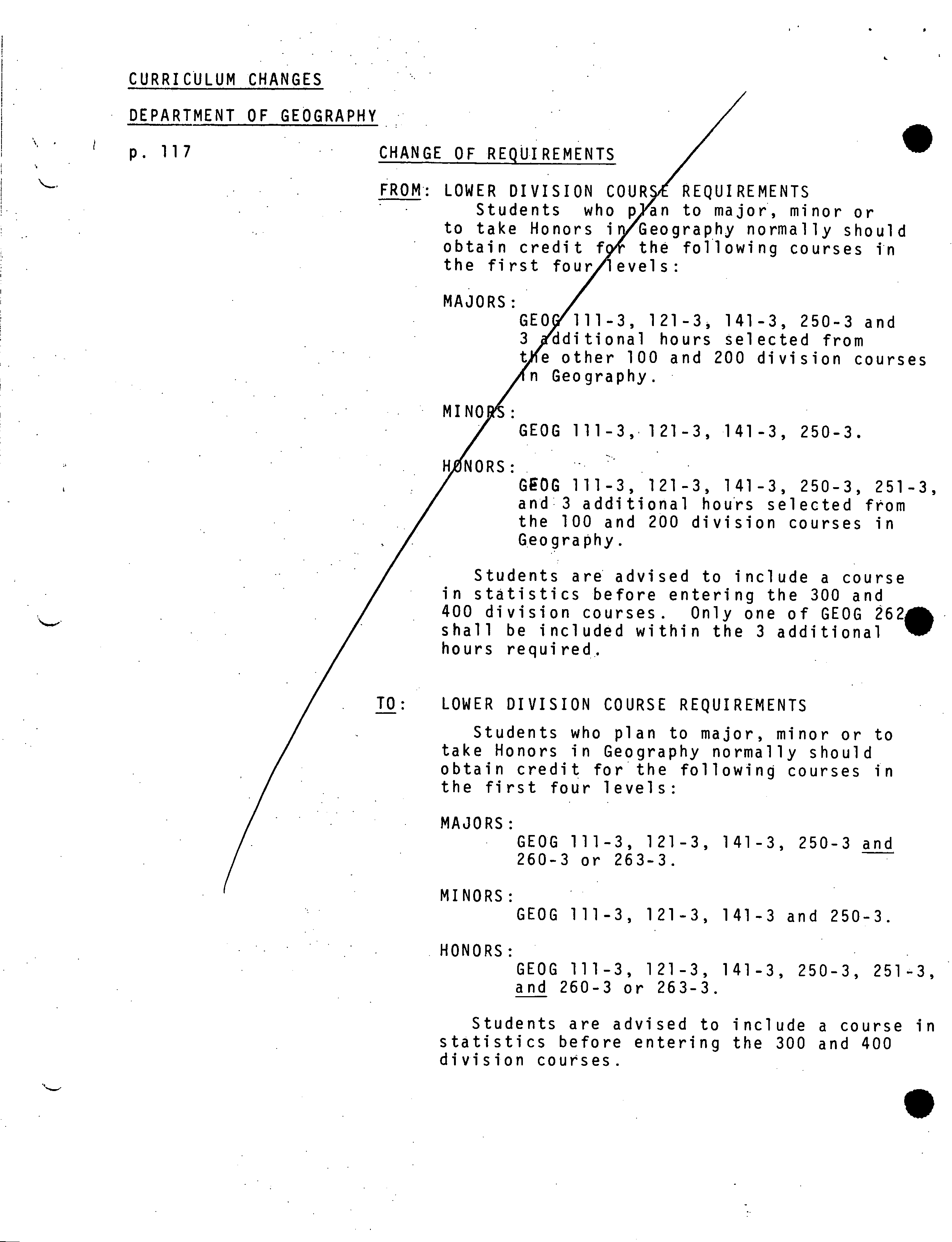
CURRICULUM CHANGES
DEPARTMENT OF GEOGRAPHY
p.
117
CHANGE OF REQUIREMENTS
FROM LOWER DIVISION COURIREQUIREMENTS
Students who pjan to major, minor or
to take Honors iy'Geography normally should
obtain credit f9* the following Courses in
the first four/levels:
MAJORS
/GEO111-3, 121-3, 141-3, 250-3 and
tional hours selected from
her 100 and 200 division courses
graphy.
MINORS:
/ ?
GEOG 111-3,.121-3, 141-3, 250-3.
H1ØNORS:
/
?
GROG 111-3, 121-3, 141-3, 250-3, 251-3,
and 3 additional hours selected from
the 100 and 200 division courses in
Geography.
Students are advised to include a course
in statistics before entering the 300 and
400 division courses.
?
Only one of GEOG 262
shall be included within the 3 additional
hours required.
TO: ?
LOWER DIVISION COURSE REQUIREMENTS
Students who plan to major, minor or to
take Honors in Geography normally should
obtain credit for the following courses in
the first four levels:
MAJORS:
GEOG 111-3, 121-3, 141-3, 250-3 and
260-3 or 263-3.
MINORS:
GEOG 111-3, 121-3, 141-3 and 250-3.
HONORS:
GEOG 111-3, 121-3, 141-3, 250-3, 251-3,
and 260-3 or 263-3.
Students are advised to include a course in
statistics before entering the 300 and 400
division courses.
9
. ?
.
S ?
S
S
.
.
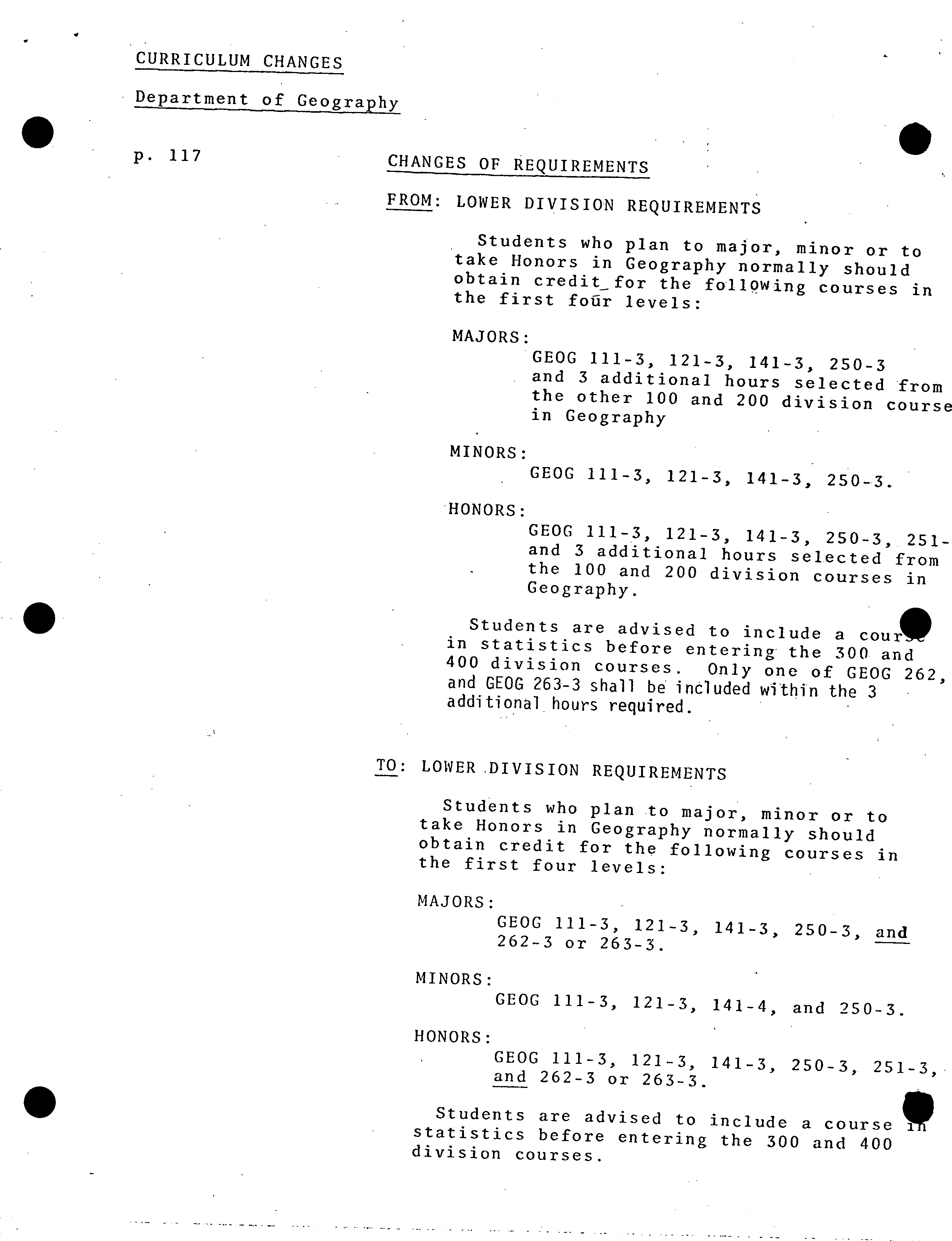
CURRICULUM CHANGES
Department of Geography
p.
117 ?
CHANGES OF REQUIREMENTS
FROM: LOWER DIVISION REQUIREMENTS
Students who plan to major, minor or to
take Honors in Geography normally should
obtain credit for the foll9Wing courses in
the first foUr levels:
MAJORS:
GEOG 111-3, 121-3, 141-3, 250-3
and 3 additional hours selected from
the other 100 and 200 division course
in Geography
MINORS:
GEOG 111-3, 121-3, 141-3, 250-3.
HONORS:
GEOG 111-3, 121-3, 141-3, 250-3, 251-
and 3 additional hours selected from
the 100 and 200 division courses in
Geography.
Students are advised to include a cour
?
in statistics before entering the 300 and
400 division courses. Only one of GEOG 262,
and GEOG 263-3 shall be included within the 3
additional hours required.
TO: LOWER DIVISION REQUIREMENTS
Students who plan to major, minor or to
take Honors in Geography normally should
obtain credit for the following courses in
the first four levels:
MAJORS:
GEOG 111-3, 121-3, 141-3, 250-3, and
262-3 or 263-3.
MINORS:
GEOG 111-3, 121-3, 141-4, and 250-3.
HONORS:
GEOG 111-3, 121-3, 141-3, 250-3, 251-3,.
and 262-3 or 263-3.
Students are advised to include a course
1
statistics before entering the 300 and 400
division courses.
.
2
p. 117 ?
FROM:
?
UPPER DIVISION COURSEREQIJIREMENTS
DIVISION STRUCTURE
DIVISION ?
A
Section I GEOG
?
313-3, ?
314-3,
315-3, ?
317-3, ?
318-3,
319-3
Section II
GEOG ?
322-3, ?
323-3, ?
324-
3,
?
325-3.
Section
III
GEOG ?
343-3, ?
344-3,
?
346-3
375-3
Section IV GEOG351-3, ?
361-3, ?
362-3,
369-3, ?
381-3,
?
382-3,
383-3, ?
385-3
DIVISION B
DIVISION C
GEOG 460-5, 461-5,
462-5, 464-5, 467-5,
469-5., 470-5
GEOG 413-5, 414-5,414-
5, 416-5, 418-5, 419-5,
420-5, 421-5, 422-5,
424-5, 425-5, 429-5,
431-5, 441-5, 444-5,
445-5, 449-5,.452-5
475-5
DIVISION D
GEOG 4.04-2, 405-4,
406-2, 407-3, 491-5,
498-5, 499-15
TO: ?
UPPER DIVISION COURSE REQUIREMENTS
DIVISION ?
A
Section ?
I
GEOG ?
312-3 ?
313-3,
314-3,
?
315-3, ?
317-3,
318-3,
?
319-3
Section ?
II
GEOG ?
322-3, ?
323-3,
324-3, ?
325-3
Section ?
III
GEOG
?
343-3, ?
344-3,
346-3,
?
375-3
Section ?
IV
GEOG
?
351-3, ?
353-3
361-3,
?
362-3, ?
369-3,
381-3, ?
382-3, ?
383-3,
385-3
DIVISION B
GEOG 413-5, 414-5,
415-5, 416-5, 418-5,
419-5, 420-5, 421-5,
422-5, 424-5, 425-5,
429-5, 431-5, 441-5,
444-5, 445-5, 449-5
452-5, 475-5
DIVISION C
'GEOG 460-5, 461-5,
462-5, 464-5, 467-5,
469-5, 470-5
DIVISION 0
?
GEOG 404-2, 405-4,
406-2, 407-3,'491-5,
4985, 499-15
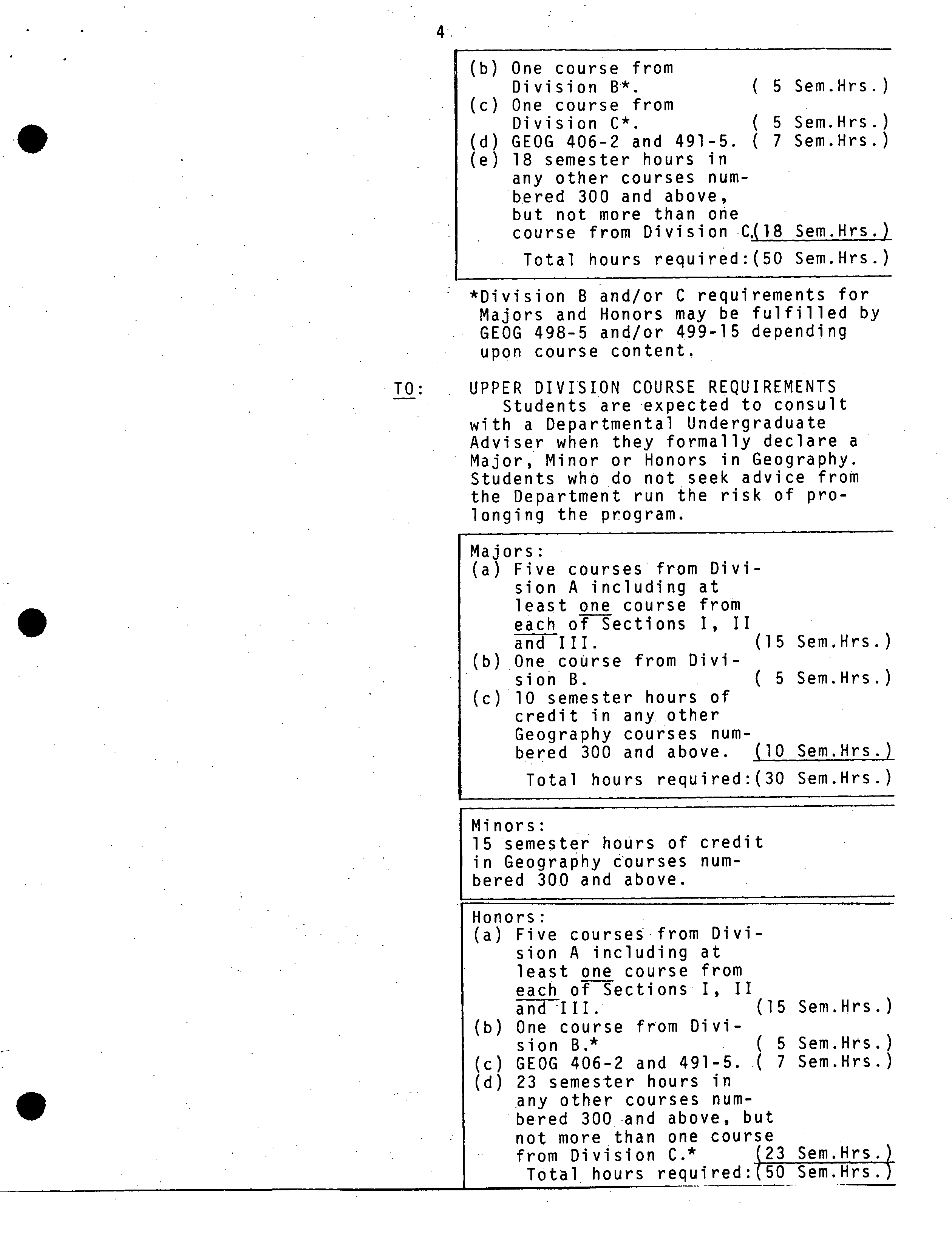
CHANGE OF REQUIREMENTS
FROM: COURSE REQUIREMENTS
Students are expected to consult.
with a Departmental Undergraduate
Adviser when they formally declare a
Major, Minor or Honors in Geography.
Students who do not seek advice from
the Department run the risk of pro-
longing the program.
Majors:
.
(a) Five ?
courses ?
from
Division ?
A ?
including
at
?
least, one ?
course
from each
?
of
?
Sections
I, ?
II ?
and ?
III.
(15
Sem.Hrs.)
(b) One ?
course ?
from ?
Divi-
sion ?
B*;
( ?
5
Sem.Hrs.)
(c) One
?
course
?
from
?
Divi-
sion ?
C*.
( ?
5 Sem.Hrs.)
(d)
5 ?
semester hours
?
of
credit
?
in
?
any
?
other
Geography ?
course ?
num-
bered ?
300 and
?
above.
( ?
5';Sem.Hrs.).
Total ?
hours ?
required:(30
Sem.Hrs.)
Minors:
15semester hours of credit
in Geography courses num-
bered 300 and above.
Honors:
(a) .
Five courses from Divi-
sion A including at
least one course from
each of Sections I, II
and III. ?
.
?
. ?
(15 Sem.Hrs.)
.
.
.
4.
(b) One course from
Division B*.
?
( 5 Sem.Hrs.)
(c)
One course from
Division C*.
?
( 5 Sem.Hrs.)
(d)
GEOG 406-2 and 491-5. ( 7 Sem.Hrs.)
(e)
18 semester hours in
any other courses num-
bered 300 and above,
but not more than one
course from Division •C.(18 Sem.Hrs.)
Total hours required:(50 Sem.Hrs.)
*Division B and/or C requirements for
Majors and Honors may be fulfilled by
GEOG 498-5 and/or 499-15 depending
upon course content.
TO: ?
UPPER DIVISION COURSE REQUIREMENTS
- ?
Students are expected to consult
with a Departmental Undergraduate
Adviser when they formally declare a
Major, Minor or Honors in Geography.
Students who do not seek advice from
the Department run the risk of pro-
longing the program.
Majors:
(a)
Five courses from Divi-
sion A including at
least one course from
each of Sections I, II
and III. ?
(15 Sem.Hrs.)
(b)
One course from Divi-
sion B.
?
( 5 Sem.Hrs.)
(c)
10 semester hours of
credit in any. other
Geography courses num-
bered 300 and above.
?
(10 Sem.Hrs.)
Total hours required:(30 Sem.Hrs.)
Minors:
15 semester hoUrs of credit
in Geography courses num-
bered 300 and above.
Honors:
(a)
Five courses from Divi-
sion A including at
least one course from
each of Sections I, II
and III.
?
(15 Sem.Hrs.)
(b)
One course from Divi-
sion B.*
?
. ?
( 5 Sem.Hrs.)
(c)
GEOG 406-2 and 491-5. ( 7 Sem.Hrs.)
(d)
23 semester hours in
any other courses num-
bered 300 and above, but
not more than one course
from Division C.
?
123 Sem.Hrs.
Total hours_required:(50 Sem.Hrs.
5.
*Division B
?
requirements for
Majors and Honors may be fulfilled
GEOG 498-5 and/or 499-1.5 depending
• upon course content.
RATIONALE: Experience has shOwn that, for most
students, regional courses provide a
far more effective vehicle for synthe-
sis in the context of the lower levels
than is the case at the advanced level.
The
,
upper-level regional courses how-
ever will remain available for
advanced study by choice rather than
requirement.
p.
120 ? . .
?
GEOG 001-3-Delete'.
GEOG 212-3-Delete. ? •
RATIONALE:. GEOG 001 is no longer seen to serve
a useful purpose. 'GEOG 212-3 is
being replaced by GEOG 312-3.
p.
121
?
, '
?
GEOG 312-3: New course - see Appendix A
p 123 ?
• ?
GEOG 353-3: New course - see Appendix.
SiMON FRASER UNIVERSITY
C.. i s
A
MEMORANDUM
To ...... Sheila
?
ober..
.
From
...........J .......
Adrriiriistrative Assistant ?
Chairman
1y•Art.s ...............................
..........
Subiect..P
e
P. ?
...........9gh..nde:-...
?
Date...........ecember .....19
graduate Program Changes
Please note that the following changes were approved by
the Department of Geography meeting of November 26 and that
I would like them included in the
1982/83
Calendar.
1. The regional requirement for majors and honors students
of one course from Division C at the upper levels is to
be eliminated and respectively 10 hours and 23 hours
(rather than the existing 5 hours and 18 hours) are now
required in any geography course numbered 300 and above in section (d).
2.
A regional course,
?
one of Geog. 2623
- or 263-3, is to be
added to the lower level requirements for majors and honors
students. This change eliminates the requirement of
1
'3 additional hours selected from the 100 and 200 division
courses in Geography".
Rationale for 1 and 2: Experience has shown that, for most
students, regional courses provide a far more effective
vehicle for synthesis in the context of thelower levels than
is the case at the advanced level. The upper level regional
courses however will remain available foradvanced study by
choice rather than requirement.
3.
Geog. 353-3 is to be added to the upper level program.
Rationale: This course is part of an emerging program in the
Department (see course proposal attachment for detailed
rationale).
. Geog. 312-3 is to be added to the upper level program.
Rationale: This course replaces Geog. 212-3 and will intro-
duce the material at a more advanced level (see course
proposal attachment for detailed rationale).
5. Geog. 001 is to be dropped from the program.
Rationale: It is no longer seen to serve a useful purpose.
THE DEAN
- ?
.
cc: G.A. Rheumer
?
fl_'1C
Q
I.M. Curtis ?
I
r,-r,r:-
iL&JLj I
1j
..
/4
NgE_c1llTT:l
.
: ON Iltil) (C'I1%.DUATF STUDIFS
Nr4
COUXS.J2.!OSiL
FORM
iL!!1!.'.111f
t!X!!W!.L,2!l
?
Department:
_
Geography
. ?
.tt.I'rivl,st ton Cude:_COCOur.w Nismbci-
:312 --
Credit .Hours:
_3_
Vector.
2-1-0
Title
uf
Couriie
GEOGRAPHY OF NATURAL HAZARDS
CtiLeiWaKIh..criptio,) o( Courni.:
The course will focus on the occurrence and origin of
natural
hazards, including volcanic eruptions
earthquakes,
landslides, avalanches,
floods, droughts, tropical storms, forest fires, pests
and
diseases. Attention will
be given to the interaction between natural processes and societies, including
attempts to predict and ameliorate the effects of natural disasters within different
cultural contexts.
N.itue of
Course
Le
.
r-+u
e e
)
Prerequisites,
(or special instructioos):
At least 30 credit hours, including GEOG 111 or 112.
What rourie
(courses), if any, is being dropped from
the
calendar if this course
Js
.pproved:?
2. Scheduln1
Ilu'1requently will, th. course be offered?
At least once a year
Stsneer in which the course will first be offered?
82-3
Which of your present faculty would be avaLlable
to
make-the proposed offering
possible?
?
M.L. Barker, C.B. Crampton, R.B. Sagar.
...
(Jbjtctives of the Course ?
'
?
To
1.
review
through
natural
the physical
hazards:processes
underlying their occurrence and in light of
[I
modern theory;
2.
by the predictive techniques and risk assessment approaches in use; and
3.
by discussion of societal adjustments in a variety of cultural contexts.
6.
H h
sd
ia t ar y
and Space Requirements (for information only)
What additional resources will be required in the following aróis:
Faculty ?
None
Staff ?
None
I.lhrary
?
Present collection does, not offer a constraint.
,tudt v ,
Visual
None
Space ?
None
Equipment ?
None
5. Approval
Date:_________________________
sb.
Dean ?
, ?
thairman, SCUS
At'ai:I,
SCUS 13-34b:-
course
(When
outline).
completing this form, for instructions see
Memorandum SCUS
Oct.
Department Chairman
71-34a.
SiMON FRASER UNIVERSITY
?
MEMORANDUM
From ......
.Mary Barker, ?
.
W ?
Chairman
...................... . .
.......
.
?
..
?
.................................
Committee
?
Subject .......
PROPOSED ?
.
300-LEVEL NATURAL
?
ate.. . .
.ovemb.... . .
?
.... . .
.
. . . . . . . . .
?
. . . . . ?
. . .
HAZARDS COURSE
Geography 212 has been offered in this department for
many years and is one of the few existing courses which
explicitly integrates biophysical and social geography. As
an understanding of extreme natural events becomes
increasingly important in western Canada (where residential,
resource, and recreational developments are penetrating
further into mountainous terrain) we feel that the course
would be more appropriately offered at the 300-level. Its
predominantly physical underpinnings makes it best suited tc
Section 1
.
of our departmental offerings, possibly as 312.
For each natural hazard, adequate supportive information
will be given as a basis for understanding the processes involved,
insofar as these are known. Attempts to predict thresholds
governing the precipitation of disastrous events, and to map
and zone hazardous environments will be treated. However,
whatever the available knowledge and predictive capacity,
different groups of people react in different ways. Why this
is so, and the repercussions of their differing perceptions will
be discussed. Rooted in physical geography, a course on
natural hazards ultimately has important cultural implications.
The course would include material and approaches covered in
Geog. 212:
1.
working definitions of natural hazards and a review
of their global significance;
2.
systematIc review of geological', atmospheric, hydrological,
and.biological hazards with respect to their origin and
occurrence, and range of possible adjustments (e.g.
protective engineering works, land-use zoning).
The content would then be expanded to incorporate a more detailed
review of societal acceptance of risk, risk assessment
methodologies, and hazard zoning techniques.
Course text
Bolt, B.A. et al., 1977. Geological Hazards. New York:
Springer verlag, 2nd edition.'
Required readings
A reserve reading list would include specialised texts
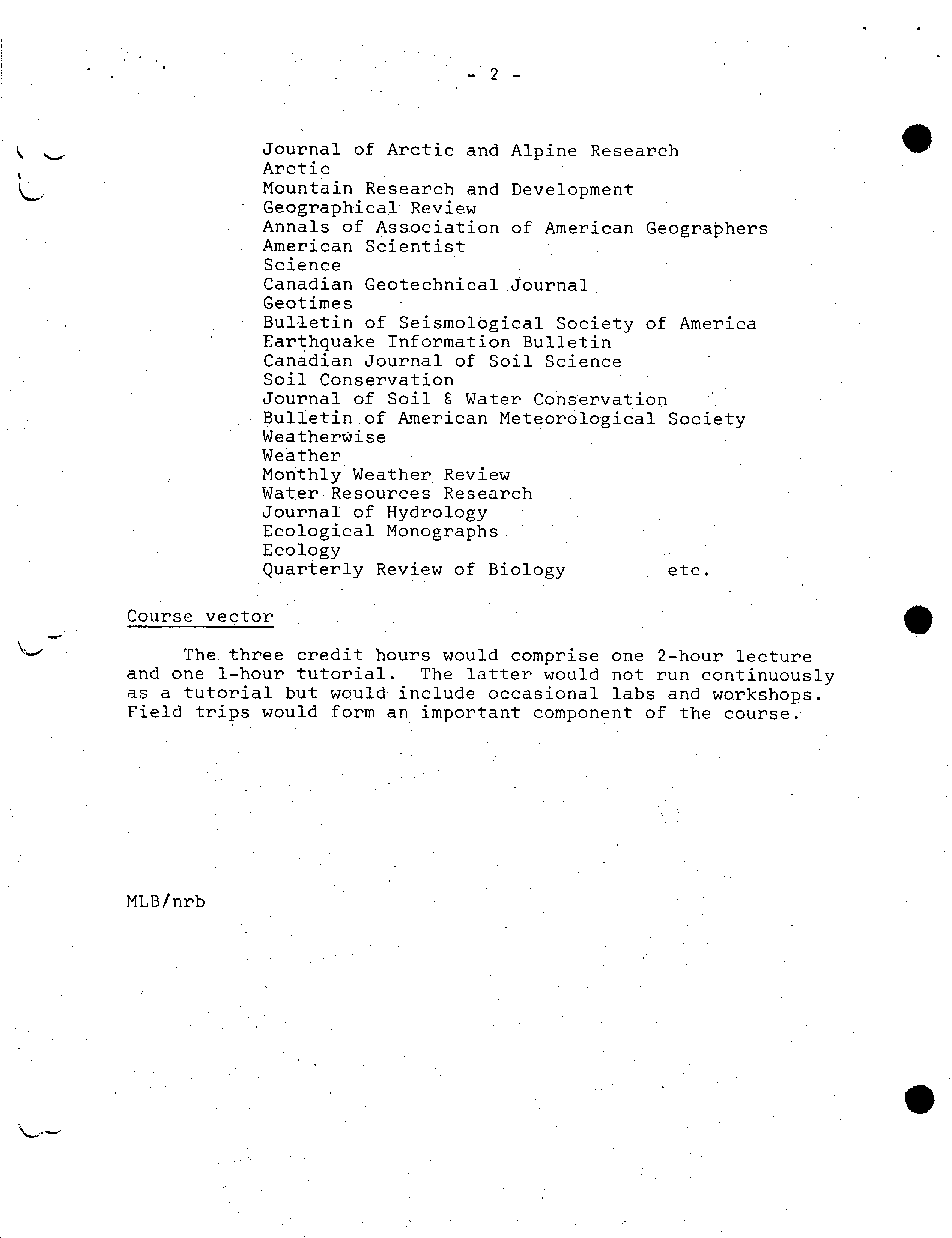
in the field and articles from the following range of journals:
-2-
.
Journal of Arctic and Alpine Research
Arctic
Mountain Research and Development
Geographical Review
Annals of Association of American Geographers
American Scientist
Science
Canadian Geotechnical Journal
Geotimes
Bulletin of Seismological Society of America
Earthquake Information Bulletin
Canadian Journal of Soil Science
Soil Conservation
Journal of Soil 6 Water Conservation
Bulletin of American Meteorological Society
Weatherwise
Weather
Monthly Weather Review
Water Resources Research
•
? Journal of Hydrology
Ecological Monographs
Ecology
•
?
Quarterly Review of Biology
?
etc.
Course vector
The three credit hours would comprise one 2-hour lecture
and one 1-hour tutorial. The latter would not run continuously
as a tutorial but would include occasional labs and workshops.
Field trips would form an important component of the course.
MLB/nrb
0
- ?
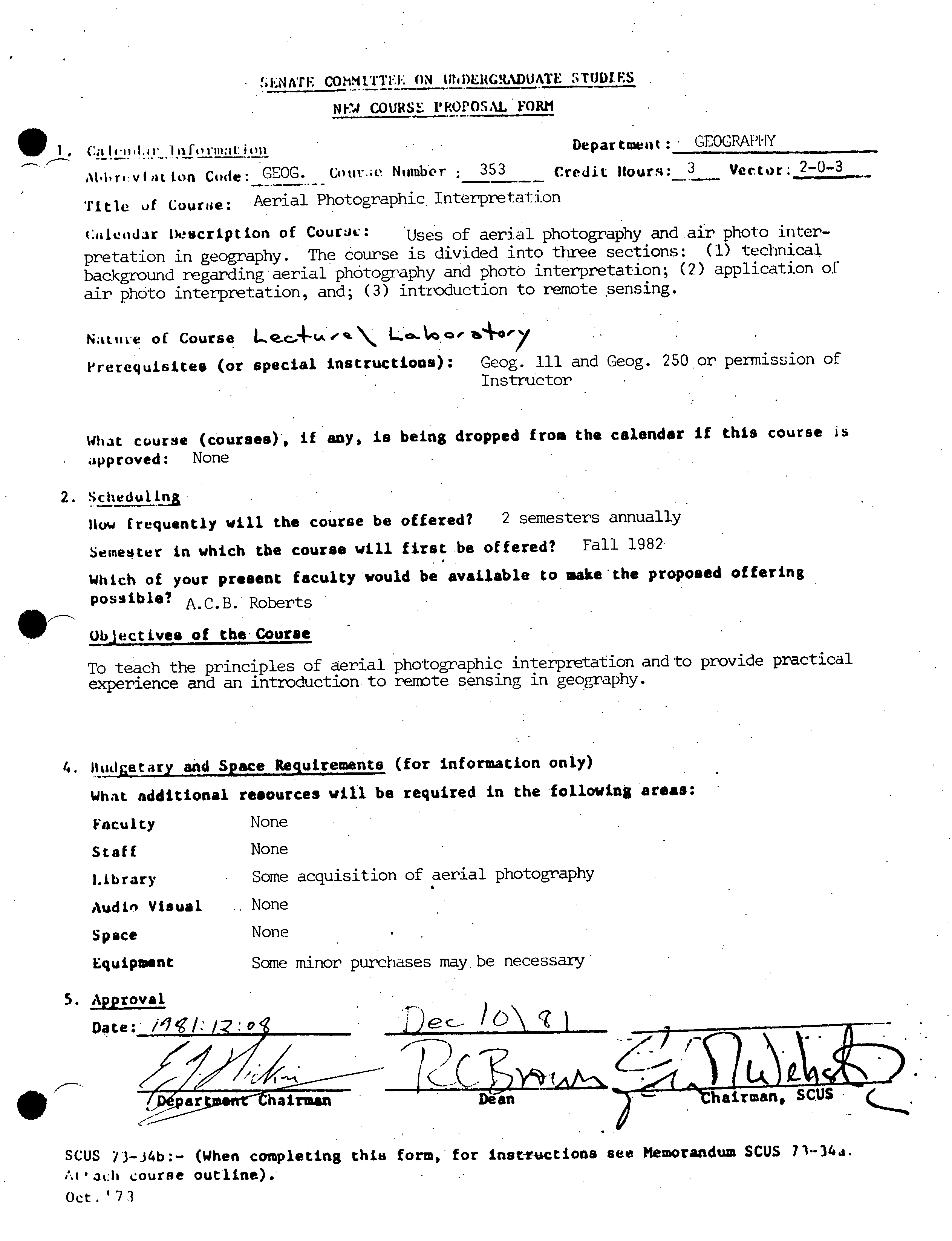
l.NAfECOMMITTIE ON tfliDERCR..DUATF. r%TIJDI.FS
NF'4 COURSE I'RO?OSAL FORM
Ca
14-1141.11
-
Iifnu.iI:ion ?
Department: ?
GEOGRAPHY
t.hri'vt t
on
Code:
GEOG. Cour.;c
Number
?
353 ?
Credit Hours:
3_
Vector.
2-03
Title
of
Courue:
Aerial Photographic .
Interpretation
:i1tiidr Description of
Cour&M..: ?
'Uses of aerial photography and air photo inter-
pretation in geography. The course is divided into three sections: (1) technical
background regarding aerial photography and photo interpretation; (2) application of
air photo interpretation, and; (3) introduction to remote sensing.
Nattue of Course
LQ.C..4isI
# .
\
Lo...#oo'
p
rerequisites (or special instructions):
Geog. ill and Geog. 250 or permission of
Instructor
What cuurse (courses), it any, is being dropped from the calendar if this course
approved:
None
2. SLI
I!
eduli nj
How
frequently will the course be offered?
2 semesters annually
Semester in which the course will first be offered?
Fall 1982
Which of your present faculty would be available to aakethe proposed offering
possible?
A.C.B. Roberts
Objectives of the' Course
To teach the principles of aerial
'
photographic interpretation and to provide practical
experience and an introduction, to remote sensing in geography.
6. Bud
g
etary and Space Requirements (for information only)
what additional resources will be required in the 'following areas:
Faculty
None
Staff
None
Library
Some acquisition of aerial photography
Audi" Visual
,,
None
Space
None
Equipment
Some minor purchases maybe necessary
5. Approval
Date:'
alc.nrthairman ?
Dean ?
?' ?
Chairmafl, SCUS
SCUS 73-34b:-
(When completing this form,' for instructions see Memorandum SCUS
7134d.
i.t'3t:II
course outline).
Oct.
1
7
3
Rationale Geog. 353
Cartography and aerial photographic interpretation have for many
years been considered as central to geographic teaching and research.
Although the SFU Geography Department has developed a strong program in
cartography and computer cartography the teaching of air photo interpretation
and remote sensing has been conducted in an off and on fashion as an
adjunct to other courses. The acquisition of a new faculty member with
specialization in aerial photography and remote sensing now permits the
department to offer an introductory course on aerial photographic inter-
pretation (Geog. 353).
This new course will provide a systematic and detailed introduction
to aerial photography, air photo interpretation and remote sensing. Upon
completion of the course the successful students will be capable photo
interpreters with practical experience in photograimnetry and preparation
of thematic maps from aerial photography.
It is anticipated that students from other departments (e.g. Archaeology
and Biology) will
,
be interested in the course. •A number of students may
wish to continue their studies in aerial photography and remote sensing and
will be qualified to enroll in the MRM 633
.
remote sensing course.
The addition of Geog. 353 as an optional course will assist in the
development of a more complete program in spatial and environmental analysis.
Geography 353-3
?
SIMON FRASER UNIVERSITY
Aerial Photographic Interpretation
?
Department of Geography
COURSE. OUTLINE
General Information
The course deals with aerial photography and air photo interpretation
as a. primary cartographic technique in geography and resource 'inventories.
The course is divided into three sections; 1) technical background regarding
aerial photography, air photo interpretation and cartography; 2) application
of air photo interpretation and resource mapping to environmental analysis,
and; 3) introduction to remote sensing. ?
.
Nine elementary laboratory exercises provide a basis for practical
experience and further study in aerial photography and related cartographic
applications.
The final grade for the course will be determined from the laboratory
assignments, a mid-term test and a final examination as follows:
Laboratory exercises
?
50%
Mid- term test
?
20%
Final examination
?
30%
The final examination must be passed' or a subsequent oral examination must
be taken by students who failed the final exam .but have sufficient marks for
a passing grade.
Supplies: Students are requested to buy
a pocket
stereoscope
and staedtler
grease pencils (red, blue, green, yellow) all other maLr'ial and instruments
will he supplied by the Department of Geography.
Text Book: AVERY, T. E., 1977, Interpretation of Aerial Photographs, 3rd idit ion,
Burgess, Minneapolis.'
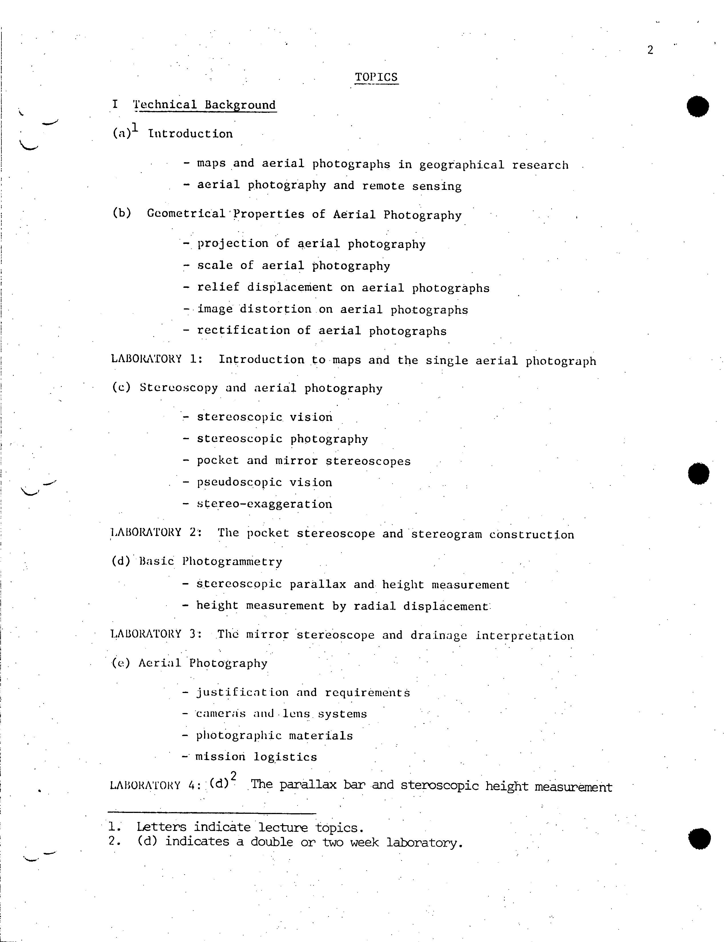
2
TOPICS
Technical Background
Introduction
- maps and aerial photographs in geographical research
- aerial photography and remote sensing
(b)
CeometricaiProperties of Aerial Photography
projection of aerial photography
- scale of aerial photography
- relief displacement on aerial photographs
- image distortion on aerial photographs
- rectification of aerial photographs
LABORATORY 1: Introduction to maps and the single aerial photograph
(c)
Stereoscopy and aerial photography
stereoscopic vision
- stereoscopic photography
- pocket and mirror stereoscopes
- pseudoscopic vision
- stereo-exaggeration
: 1i ' 1
2: The pocket stereoscope and stercogram construction
(d)
Basic Photogrammetry
- stereoscopic parallax and height measurement
- height measurement by radial displacement:
LABORATORY 3: The mirror stereoscope and drainage interpretation
(c) Aerial Photography
- justification and requirements
- cameras and lens. systems
- photographic materials
-. mission logistics
LABORATORY 4:-(d) The parallax bar and steroscopic height measurement
1.
Letters indicate lecture topics.
2.
(d) indicates a double or two week laboratory.
i.
-,
ON
3
a
(f)
Mapping
- block stereoscopic coverage
- photogrammetric triangulation
- indexes, mosaics and photomaps
- topographic and thematic mapping
- sources of aerial photographs
LABORATORY 5:.. Planning an aerial photography mission
II Applications
(g)
Interpretation of aerial photographs
- principles of photo interpretation
- direct and indirect indicators
- measurements on aerial photographs
- field and laboratory methods
- mapping through aerial photography
MID-TERN TEST
(h) Terrain analysis
- principles of analysis for geological interpretation
- landform analysis
- hydrographic analysis
- synthesis and terrain analysis
LABORATORY 6: Mapping features of alpine glaciation
(i) Vegetation analysis
- forest resources inventory
- interpretation of tree species
- analysis of vegetation patterns
LABORATORY
7: (d)
2 Mapping of tree species
(j)
Rural and agricultural land use analysis
- analysis of land use patterns
- elements of agricultural interpretation
- elements of rural settlement interpretation
LABORATORY 8: Mapping changing land use I
(k) Urban and Industrial land use analysis
- residential and commercial interpretation
industrial interpretation
- transportation networks and highway planning
LABORATORY 9: flapping changing land use II
4
III Remote Sensing
(1) Photographic Remote Sensing
- the electro-magnetic spectrum
- multi spectral photography
- colour and false colour photography
(m) Non-photographic Remote Sensing
-. passive systems
- active systems
- satellite imagery
- data processing
- Canada Centre for Remote Sensing
TEXT: AVERY, T. li. Interpretation of Aerial Photographs, 3rd edition,
Burgess Publishing Company, Minneapolis, 1977.
• Journals:
Canadian Journal of Remote Sensing, Canadian Aeronautics and Space Institute.
Photojraminetria, International Society for Photogrammetry.
Photogrammtric Engineering and Remote Sensing, American Society of
Photogrammetry.
Pliotogrrimnic t nc Record, The Photogrammet nc Society, London.
Publications of the International Training Centre for Aerial Survey,
Delft, The Netherlands, Series A: 1?liotogranirnetry, Series B:
!'hot() iiiLcrprctat ion.
5
GENERAL SOURCES
Aldred, A. H. and J. K. Hall, 1975. "Application of large scale photography
to a forest inventory", Forestry Chronicle, 51(1): 1-7.
Aldred, A. H. and L. Sayn-Wittgenstein, 1972 "Tree diameters nnd volumes from
large scale aerial photographs", Canadian Forest Service, Information
Report FMR-X-40, Ottawa.
American Society of Photogrammetry, 1968 Manual of Colour Aerial Photoqphy'
Banta Publishing Co., Menasha, Wis.
American Society of Photogrammetry, 1975 Manual of Remote Sensing, 2 vols.,
American Society of Photogrammetry, Falls Church, Va.
American Society of Photogrammetry, 1980 Manual of Photogrammetry, 4th edition,
American Society of Photogrammetry, Falls Church, Va.
Avery, T. E., 1970 Photo Interpretation for Land Managers, Kodak Publication,
•
Barrett, E. C. and C. F. Curtis (eds.) 1974 Environmental Remote Sensin:
Applications and Achievements, Edward Arnold, London.
Environmental Remote Sensing 2: Practices and Problems, Edward Arnold,
London, 1977.
Eastman Kodak Company, 1969 02tical Formulas and Their Application, Publication
AA-26, Rochester, N.Y.
Eastman Kodak Company, 1973 Specifications and Characteristics of Kodak
Aerial Films, Publication M-57, Rochester, N.Y.
llolz, R. K. (ed.), 1973 The Surveillant Science & Remote Sensing of the
Environment, Houghton Mifflin, Co.
Howard J. A., 1970 Aerial Photo-Ecology, Faber and Faber, London.
-
?
-
6
Klooster, S. A. and J. P. Scherz, 1974 "Water quality by photographic
analysis", Photogrammetric Engineering, 40: 927-935.
Kristof, S. J. and A. C. Zachary, 1974 "Mapping soil features from
multispectral scanner data", Photogrammetr:i.c Enginecrin, 40: 1427-1434.
Interdepartmental Committee on Air Surveys, 1964, 1968 "Proceedings of Seminars
on air photo interpretation in the development of Canada", Oct. 1963 and
March 1967, Ottawa.
Julesz, B., 1974 "Cooperative phenomena in binocular depth perception",
American Scientist, 62: 32-43.
Land, E. Fl., 1959 "Experiments in Colour Vision", Scientific American,
reprint.W. H. Freeman and Co., San Francisco.
Lillesand, T. M. and R. W. Kiefer, 1979 Remote Sensing and Image Interpretation,
John Wiley & Sons, Toronto.
Lintz, J. Jr. and D. S. Simonett, 1976 Remote Sensing of Environment, Addison-
Wesley Publishing Co., Advanced Book Program, Reading, Massachusetts.
Lueder, D. R., 1959 Aerial Photographic Interpretation, McGraw-Hill, N.Y.
Maugh, T. H. Ii, 1973 "ERTS: Surveying earth's resources from space",
Science, 180: 49-51.
1'laugh, T. H. II, 1973 "ERTS- (II): A new way of -viewing the earth",
Scienc, 180: 171-173.
Miller, V.
C., 1961 Photogeology, McGraw-Hill, N.Y.
Murtha, P. A., 1972
!A
guide to air photq interpretation of forest damage
in Canada", Forest Management Institute, Canadian Forestry Service-,
Publication 1292, Ottawa.
Nielsen, U. ,
1.974 "Descript-iort and performance of the forestry rad.r altimeter",
Forest
Management Institute, Canadian Forestry Service, Ottawa.
S
-
7
Sdiul , C. It., and Pt. C. vanWijk, 1965 "The determination of tree he:ighL:
from parallax measurements", Canadian Surveyor, 19: 415-427.
Ulliman, J. J., 1975 "Cost of aerial photography", PhotogrammetricEngeedn
andRemote Sensing, 41: 491-497.
Veign, J. C. and F. B. Reeves, 1973 "A case for orthophoto mapping"
Photogrammetric Engineering, 39: 1059-1063.
Way, D. S., 1978 Terrain Analysis, 2nd Edition, Dowden, Hutchinson & Ross,
Stroudsburg, Pennsylvania.
Wronski, W. and K. J. Davies, Photo Interpretation for Planners, Kodak
Publication, M-81.
Zsilinszky, U. C., 1966 Photographic Interpretation of Tree Species In Ontario,
2nd ed., Ontario Department of Lands and Forests.